
Arminghall Timber Circle and Henge
The Later Prehistoric Norfolk Project¹ is an archaeological research programme examining key aspects of the landscape between the Neolithic (4,000 BCE) and the end of the Iron Age (43 CE). Work to date has focused on the landscapes around two monuments, Arminghall Timber Circle and Henge and Warham Camp Iron Age Fort. Both these monuments were central to their surroundings and acted as focal points for gatherings of people. Broadly, the project is interested in how central places developed in these landscapes and the way in which people gathered in groups at special places. This page focuses on the work undertaken by the project at Arminghall.
From its beginnings the project was designed as a community-based project with a central goal of focusing on the health and well-being of participants and facilitating educational opportunities and skills development. Participants came to the project via general calls through archaeological and heritage organisations, from social prescribing and as a result of high school and college extra-curricular calls.
Arminghall Timber Circle and Henge (NGR TG 239 060) see Norfolk Heritage Explorer and Historic England, is a Schedule Monument sitting on a gravel terrace above the River Tas, close to its confluence with the River Yare around 3km south of Norwich, near the village of Trowse.
The site was discovered on a clear day in June 1929 by Wing Commander Gilbert Insall VC during an aerial archaeological survey, a subject that he pioneered. Insall was, by this time, getting good at spotting a range of archaeological remains, including evidence of prehistoric timber monuments, having four years earlier discovered Woodhenge near Stonehenge in Wiltshire.
Soon after Arminghall’s discovery Grahame Clark, working in the Department of Archaeology and Ethnography at the University of Cambridge, visited it in 1934 and became worried about its continuing survival in a part of suburban Norwich that was increasingly threatened by infrastructural development for services supplying the growing city, including a large electricity pylon built into the confines of the monument. Work on the surrounding landscape, including Insall’s photos, had established there were many monuments in the immediate vicinity, including concentrations of ring-ditches, the remains of round-barrow burial monuments. Another, more difficult to interpret monument, consisting of a D-shaped enclosure and a double ring-ditch lay close by at Markshall with multiple cropmarks seen through aerial photographs. Clark set about planning an excavation to better characterise and understand Arminghall which and began the work in 1935.
Clark had a short window to undertake the investigations, just five weeks during August and September. He had assembled a team of archaeologists including Rainbird Clarke, C.W. Phillips and Mollie White. Both Rainbird Clarke and Charles Phillips went onto illustrious careers, Clarke as Curator and later Keeper of archaeology at Norwich Castle Museum and Phillips taking over the excavations of the ship burial in Mound 1 at Sutton Hoo in 1939.
These investigations unpicked the monument’s components and its chronology. It showed that the eight central postholes were all large, possessing post-pipes measuring around 1m diameter and were embedded 2.7m into the gravels, indicating that very large posts made up the circle. These excavations also recorded pottery from the base of the inner henge ditch identified as rustic Beaker. This provided a date for the monument at the beginning of the Bronze Age.
This loose attribution remained for the monument until the opportunity to obtain a radiocarbon date arose with the British Museum lab becoming operational in 1959. A sample was analysed from post hole 7 in 1960 and the date came back as 4440±150BP (before present, or c. 2400 BCE). This confirmed a very early Bronze Age status for the monument until later calibration work in the mid-2000s refined it to 3525-2700 cal BCE significantly, potentially much earlier and placing the one dated timber post in the Neolithic (4000-2400 BCE). This broad date range lacked clarity and provided a good reason to return to Arminghall and take further samples.
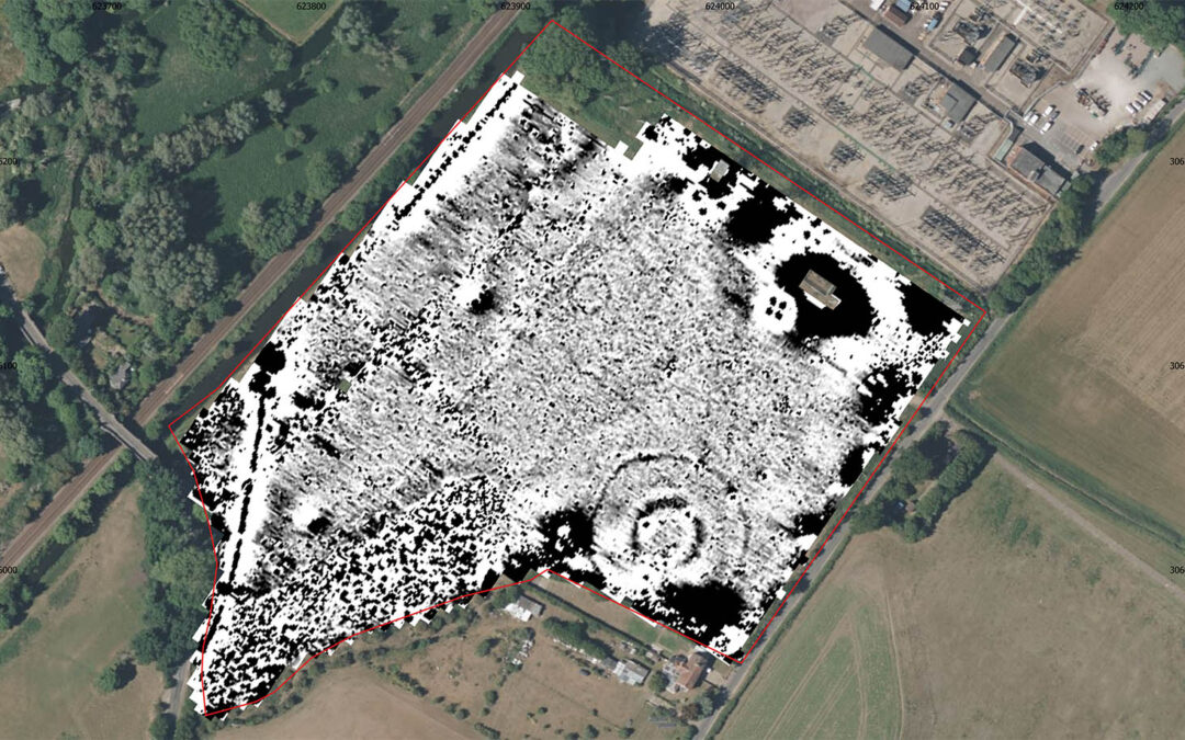
The 2022 investigations followed literally in Clark’s footprints, reopening the 1935 trench and adding in a small amount of new excavation to investigate post hole 2 and reexamine post hole 3. It also allowed the team to have another look at the layers within the henge ditches too. Geophysical survey was done of the whole of the field in which the monument sits and several trenches outside of the monument were dug to examine the deposits.
Our work demonstrated that the timber posts within post hoes 2 and 3 had both been removed leaving identical patterns in the section through the deposits. This pattern leads us to believe that the timber posts were burnt while still standing and then laboriously removed from the ground leaving an angled smudge where they were pulled up. This in turn suggests that the whole timber circle had been put to the flame effectively bringing it to an end. Burnt material, charcoal and scorching of the gravel base of the henge ditch indicate that this conflagration took place after the henge had been built around the timber circle.
Our next steps are to publish the results of our work including several new radiocarbon dates which help to define the history of the monument. This work is due for completion soon, so watch this space.
1. The project is a partnership with a range of organisations and participants taking part. At its core have been the Sainsbury Institute for the Study of Japanese Arts and Cultures, UEA more generally, Cambridge Archaeological Unit, the Restoration Trust, Synergy-multi Academy Trust and Norfolk and Norwich Archaeological Society. Funding has been generously provided by the National Heritage Lottery Fund, the Society of Antiquaries and Norfolk and Norwich Archaeological Society.


